


Video: https://www.youtube.com/watch?v=1DO_0ov4_aM&t=316s
Our world is full of mysteries and secrets. The dream of every person is to travel around the planet, having traveled around the most intimate places and seeing the most mysterious corners of the earth. Indeed, there are a huge number of places in the world that simply fascinate with their history and beauty! However, few could have imagined that there are places on Earth that are strictly forbidden to visit due to danger or inaccessibility. Maybe they want to hide the most secret, unseen and hidden from human eyes. Today we will tell you about one of these places.
In the southwestern part of the Aral Sea, on the border between Kazakhstan and Uzbekistan, there is an island surrounded by kilometers of toxic desert. But once, it was a lively fishing village surrounded by the turquoise lagoons of the Aral Sea which was the fourth-largest sea in the world. Huge herds of saiga antelopes grazed on an area of 216 km² that overgrown with bushes, and two bays were rich in fish and waterfowl.
This piece of land remained such a paradise for exactly one hundred years, until the end of 1948, when, in connection with the construction of a military biochemical test site, the civilian population was evicted from the island. Since that time, the island has become inaccessible for hunters and fishermen.
At the end of the 1920s, the command of the Workers and Peasants of the Red Army was concerned with choosing a location for a scientific center for development of biological weapons and testing polygon. For this purpose, it was necessary to select a relatively large island with a distance from the coast of at least 5-10 kilometers. They even looked for a suitable candidate on Lake Baikal, but in the end, they decided to stop at three objects: the Solovetsky Islands in the White Sea, the single Gorodomlya islands on Lake Seliger and Vozrozhdenie in the Aral Sea.

The Island Vozrozhdenie was perfect for this purpose. This unpopulated piece of land in the Aral Sea that is an endless salt lake on the border of Kazakhstan and Uzbekistan was discovered in 1848. The lifeless archipelago, where there was no fresh water, was called the Tsar’s Islands, and its constituent parts – the islands of Nikolai, Constantine and the Heir. The island Nikolai was renamed to Vozrozhdenie Island that after the war became a top-secret Soviet base-proving ground for testing deadly diseases. The territory was considered secret and was not marked on any of the world maps. The secrecy was so high that even the staff working at the polygon did not know where they were.
At first glance, the island met all safety requirements: practically uninhabited surroundings, flat terrain, and hot climate, unsuitable for the survival of pathogenic organisms.
In the summer of 1936, the first expedition of military biologists headed by Professor Ivan Velikanov, the father of the Soviet bacteriological program, landed here. The island was taken away from the jurisdiction of the NKVD, the exiled kulaks were evicted from here, and the following year they tested some bioagents based on tularemia, plague and cholera.
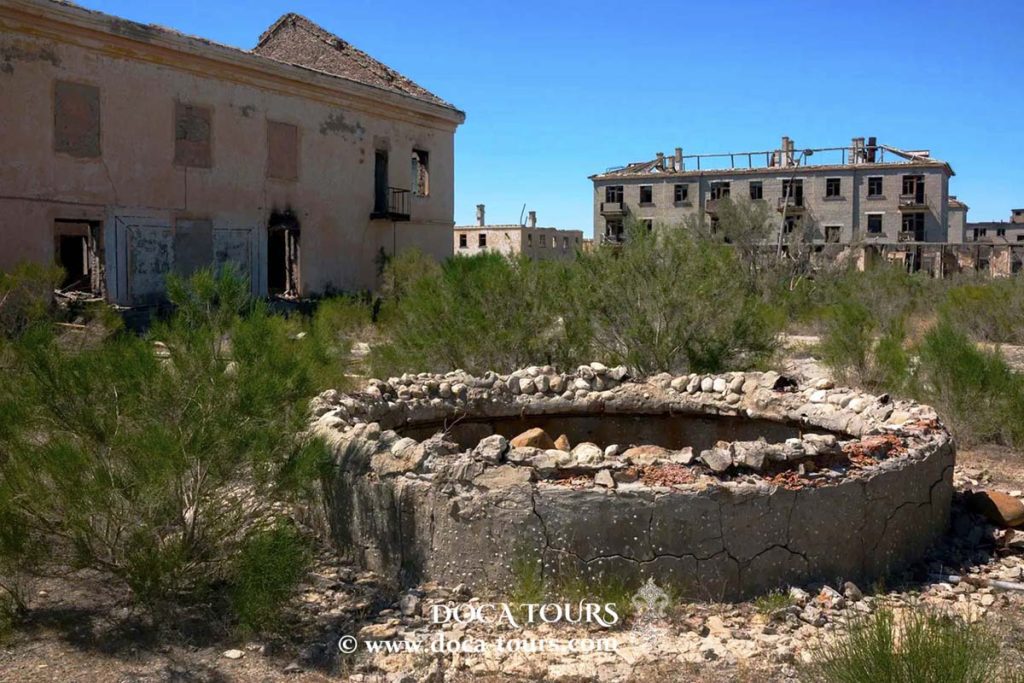
In the northern part of the island, the military town of Kantubek was built, officially named Aralsk-7. In general, it looked like hundreds of its other counterparts that emerged in the vastness of the Soviet Union: a dozen or so residential buildings for officers and scientific personnel, a club, a canteen, a stadium, shops, barracks and parade ground, its own power station.
Near the village was built a unique airfield “Barkhan” that was the only one in the Soviet Union that had four runways resembling a wind rose.

Simultaneously with the training polygon, a stud farm was built on the Kulandy Peninsula – specifically for the needs of the military. Dozens of horses were transported to the island: some were tested, but from most of them took blood to prepare serum – a nutrient medium for breeding deadly strains. The corpses of horses were buried somewhere in remote areas of the island.
In total, there were up to one and a half thousand soldiers and their families on the island. It was, in fact, an ordinary garrison life, the features of which were perhaps the special secrecy of the facility and the not very comfortable climate. Children went to school, their parents went to work, in the evenings they watched movies in the officers’ house, and on weekends they had picnics on the shores of the Aral Sea, which until the mid-1980s really looked like the sea.
With the nearest city on the “mainland”, Aralsk, there was a sea connection. Fresh water was also delivered here in barges, which was then stored in special huge tanks on the outskirts of the village.
A laboratory complex was built a few kilometers from the village, where, among other things, experimental animals were kept, which became the main victims of the tests carried out here. In 1980, specially for experiment, through the USSR Foreign Trade, a batch of 500 monkeys was purchased from Africa. All of them eventually became victims of the tularemia microbe strain, after which their corpses were burned, and the resulting ashes were buried on the island.
The southern part of the island was occupied by the actual test site. It was here that shells were blown up or pathogenic strains based on anthrax, plague, tularemia, Q fever, brucellosis, glanders, and other especially dangerous infections were blown up or sprayed from an aircraft, as well as a large number of artificially created biological agents.
The most frightening thing was that in order to study the scale of the spread of bacteriological aerosol in the atmosphere, tests were carried out in the upper layers of the island’s air sphere. During the tests, it was dangerous to be near the island, especially in its southern part, because it was there that aerial experimental tests were carried out. During the experiments, everything around was covered with a greenish fog.
Since 1970, emergencies began to occur in the Aral Sea. In 1971, a research boat sailing in the sea is carried away by the wind far from the coast and it fell into a dense green fog. As part of the expedition, a young woman scientist got sick. Upon returning to the city, she was diagnosed with smallpox. After a while, she recovered, but the infection was transmitted to 9 more people, and three of them, including her brother, died.
A year later, in a boat sailing off the coast of the island, the bodies of two previously missing fishermen were found. It is established that the cause of death was an epizootic.
After some time, the local population caught a huge amount of dead fish in the sea. Nobody understood the reason for this. And in May 1988, in the steppe area of the island, a large herd of saigas of 50 thousand heads perished within an hour.
It is concluded that the reason for these events is the experimental tests of bacteriological weapons conducted on the island.
It was noted that bacteriological weapons were also tested in the air.
Simultaneously with the post-war intensification of military scientific work on the Vozrozhdeniye Island, the Soviet leadership initiated an environmental catastrophe, which ultimately led to the colossal degradation of the Aral Sea.
The main source of recharge for the lake-sea was the Amu Darya and the Syr Darya. In total, these two largest rivers of Central Asia supplied about 60 cubic kilometers of water to the Aral Sea per year. In the 1960s, the waters of these rivers began to be sorted out by reclamation canals – it was decided to turn the surrounding deserts into a garden and grow cotton there so much needed by the national economy.
The result was not long in coming: the cotton harvest, of course, increased, but the Aral Sea began to rapidly grow shallow.
In the early 1970s, the amount of river water that reached the sea decreased by a third, after another decade, only 15 cubic kilometers per year began to flow into the Aral Sea, and in the mid-1980s this figure completely dropped to 1 cubic kilometer. By 2001, the sea level dropped by 20 meters, the volume of water decreased 3 times, the area of the water surface – 2 times. The Aral was divided into two large lakes not connected with each other and many small ones. In the future, the shallowing process continued.

Due to the shallowing of the sea, the area of the Vozrozhdeniye Island began to increase just as rapidly – and in the 1990s it grew almost 10 times. The Tsar’s Islands first merged into one island, and in the 2000s it merged with the “mainland” and turned, in fact, into a peninsula.
The collapse of the USSR finally “buried” the test site on the Vozrozhdeniye Island. Weapons of mass destruction turned into an entity of little relevance in post-Soviet realities, and in November 1991 the military biological laboratory Aralsk-7 was closed. The population of the village was evacuated within a few weeks, all the infrastructure (residential and laboratory), equipment were abandoned, Kantubek turned into a ghost town.
The place of the military was quickly taken by marauders, who in their own way appreciated the wealth of the former top-secret scientific center left by the army and scientists. Everything that was of any value and at the same time amenable to dismantling and transportation was removed from the island. Kantubek-Aralsk-7 has become an elusive dream for fans of abandoned cities.
The abandoned polygon in the Aral Sea is still considered the largest biological weapons cemetery in the world. Currently, the northeastern part of the Aral Sea has dried up completely. Vozrozhdenie Island in the south was connected with the Ustyurt plateau, with the mainland and turned into a peninsula. It is not difficult to assume that the bridge between it and the mainland makes it easy for infected animals to migrate “to the mainland” and visit curious animals and marauders. Meanwhile, at the present time, every year the danger of the spread of infection may be aggravated, since the Aral Sea is rapidly shallowing, and, accordingly, the former island increases in size and turns into the Peninsula of Death.
So, is the territory of Vozrozhdenie Island dangerous or not? This question is still open.
In many countries, in particular in Chernobyl, ghost towns are used for tourism purposes.
At present, wells are being dug on the territory near the island – on the Chagall massif – a green oasis is being created in order to increase the tourist potential. And the island is being reborn according to its name.
Thank you very much for your attention.
Subscribe to the channel and don’t forget to like our videos.
#town, #city, #cityscape, #landscape, #building, #mountain, #travel, #tourism, #south, #cape, #africa, #architecture, #urban, #view, #aerial, #ocean, #street, #sea, #house, #waterfront, #harbor, #skyline, #sky, #scenic, #water, #overhead, #scenery, #landmark, #tourist, #outdoor, #above, #table, #panoramic, #modern, #blue, #peak, #downtown, #flat, #background, #scene, #home, #stadium, #bay, #western cape, #panorama, #vector, #cape town, #pier, #design, #horizontal