


Video: https://www.youtube.com/watch?v=o4qvbQQa_pU&t=15s
The Pamir Road is one of the most spectacular roads in the world and the highest mountain route in Tajikistan and Kyrgyzstan.
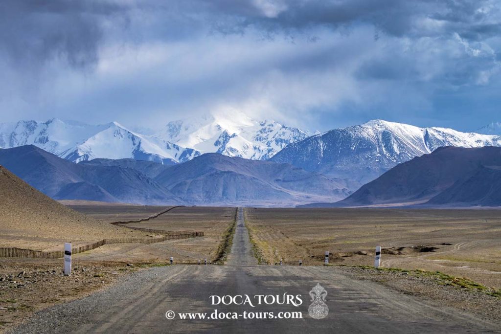
A special feature of this road is that it passes at altitudes ranging from 900 to 4655 meters, and the route runs through the picturesque mountainous regions of the Pamirs. Because of the harsh mountain climate, the quality of the road can be called extreme in many sections.
We would like to tell you about the final part of the Pamir Tract – from Murghab to Karakul is considered to be the highest mountain stage of the route. In the meantime, you can subscribe to our channel and like the video after watching it. Interesting and useful travel videos about Central Asia are waiting for you. We are starting.
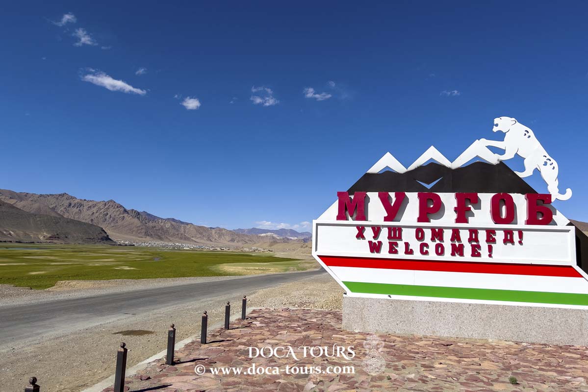
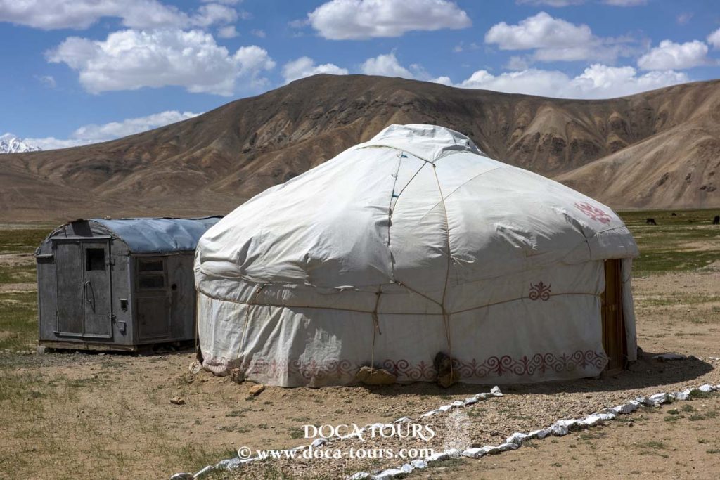
We started our journey from Murghab city located in the eastern part of Tajikistan. Murgab is considered the most high-mountain city in the territory of CIS. It lies at the junction of the Pamir highway that runs through the center of the town and connects it with Kyrgyzstan and Afghanistan, and also the main road linking Tajikistan with China via the Kulma Mountain pass.
The city was built during the Soviet era and is an important transport hub as well as the largest city in the eastern Gorno-Badakhshan territory. Most of its residents are ethnic Kyrgyz, but they live in dwellings more typical of Tajiks. Recently, Murghab has become an important tourist base and is one of the few places in Tajikistan that has tourist facilities, including community-based tourism.
After passing through Murghab, we kept on our way toward the Kulma Pass, which is along the border with China. On the Chinese side, 12km from the pass is the village of Karasu. The pass was closed for a long time, first because of deteriorating Soviet-Chinese relations, then because of the civil war in Tajikistan. In 1997, Tajikistan and China signed an agreement to establish a trade corridor between the two countries through the pass, which would significantly reduce the delivery time of goods. The pass was not officially opened until May 25, 2004. Every year there has been a significant increase in the number of goods transported through the pass.
Having passed the Kulma Pass, we headed towards Akbaytal, which means “white mare” in Kyrgyz.
The height of the pass is 4655 meters. Akbaital is considered to be the highest point of the Pamir tract. The pass itself consists of several steep serpentines and a flat, straight unpaved road at the top. Some people find it rather difficult to make even a few steps to making photos of the surroundings and suffer from shortness of breath. Still, the altitude is decent. The pass is open all year round and connects Sarykol and Muzkol ridges and separates the Karakul Lake basin from the headwaters of the South Akbaital river (Murghab basin).
The approach from the Muzkol valley is relatively gentle but steeper on the southern side with several steep turns. The scenery is very mesmerizing, with views of several glaciers at over 5,000 meters. This pass was opened to vehicles in 1892 during the construction of the Russian military outpost.
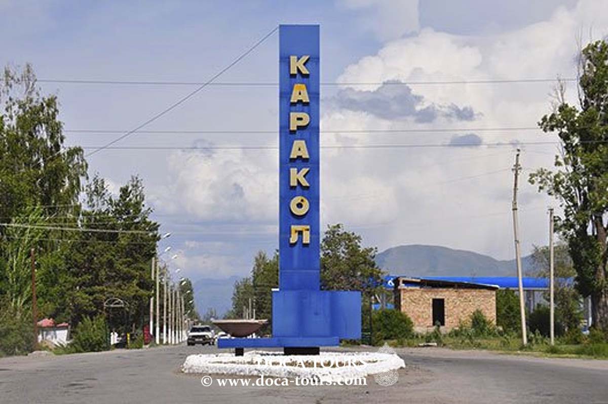
After the pass, the mountains part slightly, opening up the valley which can only be called a “high-mountainous desert”. The high-mountainous Lake Karakul is not far away.
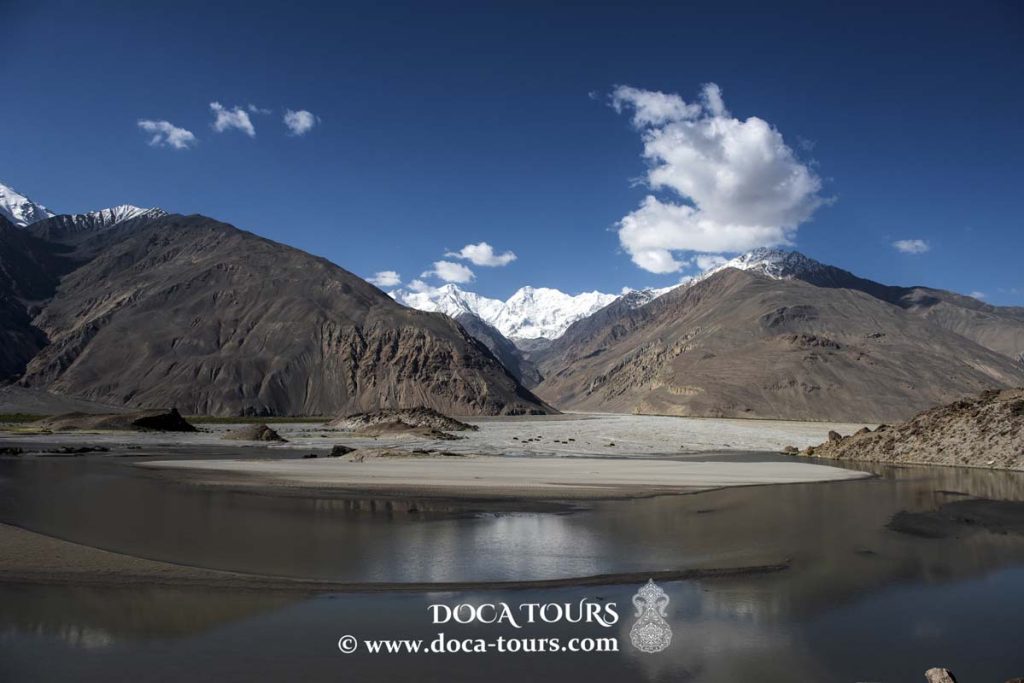
Lake Karakul has an area of 380 km2, its length from north to south is 33 km, and from east to west is 24 km. In the middle is a huge island, which divides Karakul into two parts: the eastern part is 22 meters deep and has smooth slopes to the water; the western part is more abrupt and here the depth reaches a mark of 236 meters. Although this brainless lake is fed by glaciers from the surrounding mountains, the water in Karakul is salty.
The beauty of Lake Karakul is brought not only by its bright blue color but also by the picturesque landscape reflected in the water by the snow-white peaks of the Pamirs. Around the lake, there is a chain of seven thousand, among which Lenin Peak and Avicenna Peak are especially notable. Also, due to the high altitude, the sky seems closer and has a deeper color, and at night the Milky Way shines brightly over the lake.
Lake Karakul attracts travelers with its beauty of unspoiled nature and remoteness from people. The place is often visited by car and motorbike tourists. Mountaineering groups and rafting enthusiasts ply their routes along the rapid, rapids rivers.
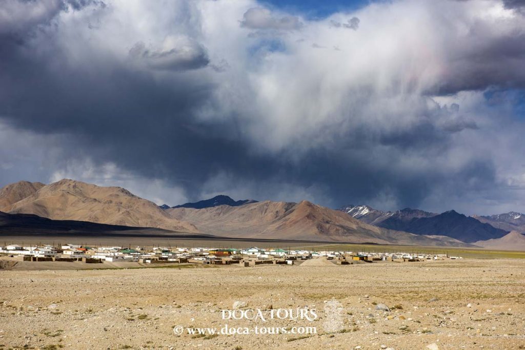
Located on the eastern shore of the lake, Karakul resembles a post-apocalyptic settlement. The one-storey clay houses are painted white in places, and the lack of a layout forms a small labyrinth. Mostly, Kyrgyz live there, and it is only 50km from the Kyrgyz border. There is no infrastructure in the village, only a small school and a couple of guesthouses where you can stay for lunch or a night. In addition, electricity is only turned on in the morning and evening.
Travelers in the area also visit the Markansu valley, which is pebbly and lifeless, also known as Death Valley because of the large number of dead camel, horse, and donkey bones which used to be the caravan route.
“Adventure gives us joy. And joy, after all, is the purpose of life. We don’t live to eat or make money. We eat and earn money to be able to enjoy ourselves. That is the meaning of life, and that is what it is given for.”
GEORGE MALLORY
And our release isn’t over at this point. Push the like button if you like the video. Moreover, we would like to inform you about our new youtube channel “kishlak life” (urban life), where you can watch authentic rural life in Central Asia. Subscribe and get surprised.
Travel together with DOCA TOURS. See you soon!
The Pamir Road is one of the most spectacular roads in the world and the highest mountain route in Tajikistan and Kyrgyzstan.
A special feature of this road is that it passes at altitudes ranging from 900 to 4655 meters, and the route runs through the picturesque mountainous regions of the Pamirs. Because of the harsh mountain climate, the quality of the road can be called extreme in many sections.
We started our journey from Murghab city located in the eastern part of Tajikistan. Murgab is considered the most high-mountain city in the territory of CIS. It lies at the junction of the Pamir highway that runs through the center of the town and connects it with Kyrgyzstan and Afghanistan, and also the main road linking Tajikistan with China via the Kulma Mountain pass.
Thank you very much for your attention.
Subscribe to the channel and don’t forget to like our videos.
#dushanbe, #arbol, #kalaykumb, #khorog, #nature, #tajikistan, #flower, #pinkflowers, #summer, #gardening, #lythraceae, #lagerstroemiaindica, #lagerstroemia, #jardin, #plant, #garden, #central asia, #landscape, #tree, #flores, #beautiful, #color, #pink, #petal, #bonsai, #background, #closeup, #spring, #bloom, #botany, #leaf, #blossom, #floweringtree, #naturephotography, #repemyrtle, #natural, #green, #colorful, #fresh, #floral, #purple, #blooming, #plantas, #naturelovers, #crapemyrtle, #plantsofinstagram, #violet, #close-up, #arboldejupiter, #flowerstagram